
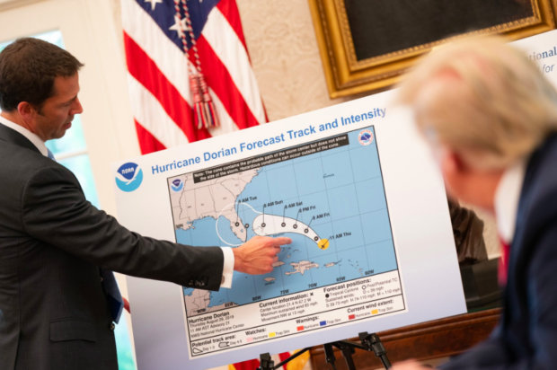
(Photo by Chip Somodevilla/Getty Images)
How does crazy shit like this even happen? How does Donald Trump wind up on national television next to a weather map which has very clearly been doctored with a Sharpie to put the state of Alabama in Hurricane Dorian’s path?
https://twitter.com/wxdam/status/1169308075662151680?s=20

Legal Is Changing. And NeoSummit Is Where The Future Is Being Built.
Legal and operational leaders are gathering May 6–7 in Fort Lauderdale to confront the questions the industry hasn't answered—with a keynote from Amanda Knox setting the tone.
DHS director Kevin McAleenan cannot possibly have showed up in the Oval Office with that map. The man is not a complete idiot; he’d at least have used Wite-Out.
But you know who does like to write in Sharpie?
Trump notes captured by @jabinbotsford:
“They want to impeach me over acts that they did”
“Dems have no achomlishments [sic]”https://t.co/WUGczy4y2c pic.twitter.com/ealXzJEFJM— Dan Eggen (@DanEggenWPost) May 22, 2019
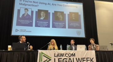
What Even Is AI ‘Competence’? It Depends.
Takeaways from a Legalweek panel on evolving malpractice risks.
And indeed Bloomberg confirmed that Trump “personally altered” the weather prediction, adding “Doctoring Weather Maps” to his list of, uh … “achomlishments.”
But he’s a modest fellow, so he demurred when asked if he colored that pretty picture all by himself.
REPORTER: That map you showed us today, it looked like it almost had like a Sharpie on it.
TRUMP: I don’t know, I don’t know, I don’t know. pic.twitter.com/d2oZemOshh
— JM Rieger (@RiegerReport) September 4, 2019
The president repeatedly insisted on Sunday that Hurricane Dorian was going to strike the Atlantic coast and the Gulf Coast, spreading destruction clear across the Florida panhandle into Alabama, while simultaneously wreaking havoc in Georgia and the Carolinas. Whether the inclusion of the Yellowhammer State in storm’s flightpath “just came up” or was from “original scenarios” Trump could not say. But it was most definitely not forecast on Sunday, August 29, when Trump was telling Alabama to stay safe.
Here’s Donald Trump receiving a briefing on Sunday, September 1, inexplicably using a real map that was already three days out of date, but still showed no danger to Alabama. (Only the best people!)
(Official White House Photo by Shealah Craighead / Public Domain)
Which didn’t stop him from scream-tweeting at ABC’s Jon Karl for pointing out that he’d pulled that threat to Alabama out of his ample rear end.
….when in fact, under certain original scenarios, it was in fact correct that Alabama could have received some “hurt.” Always good to be prepared! But the Fake News is only interested in demeaning and belittling. Didn’t play my whole sentence or statement. Bad people!
— Donald J. Trump (@realDonaldTrump) September 2, 2019
Why would Trump use an outdated hurricane map from August 29 on September 1 and again yesterday on the 4th, albeit in Sharpie-edited form? To prove his detractors wrong, of course!
It was going toward the Gulf. That was what was originally projected, and it took a right turn and ultimately — hopefully, we’re going to be lucky.
No doubt the New York Times will accuse President Geography Bee of being “meteorologically insensitive.” But here on Planet Earth, it was never “going toward the Gulf.” That would be … A LIE.
And yet, he’s arglebargling still, citing ever-earlier forecasts to prove somehow that Alabama was actually in danger on Sunday.
This was the originally projected path of the Hurricane in its early stages. As you can see, almost all models predicted it to go through Florida also hitting Georgia and Alabama. I accept the Fake News apologies! pic.twitter.com/0uCT0Qvyo6
— Donald J. Trump (@realDonaldTrump) September 4, 2019
Can we zoom in on the date there?

How is this even real? And what does it have to do with the law, aside from the 25th Amendment solution, which is clearly never going to happen since Cabinet members Kevin McAleenan and Alex Azar sat right there looking at this week-old, defaced map like it was totally normal.
Well, as Forbes science writer Dennis Mersereau pointed out on Twitter,
18 U.S. Code §2704 provides that:
Whoever knowingly issues or publishes any counterfeit weather forecast or warning of weather conditions falsely representing such forecast or warning to have been issued or published by the Weather Bureau, United States Signal Service, or other branch of the Government service, shall be fined under this title or imprisoned not more than ninety days, or both.
And this “counterfeit weather forecast” which Trump falsely attributed to the National Weather Service, pretty clearly fits the bill.
No doubt Attorney General Barr will get right on it. But probably he’ll wait ’til after the holidays, since he booked that $30,000 Christmas party at the Trump International Hotel in D.C., and it would be such a downer to lose his deposit.
THIS IS FINE.
Trump Altered Dorian Map to Show Storm Threatened Alabama [Bloomberg]
Elizabeth Dye lives in Baltimore where she writes about law and politics.